Don’t hesitate to contact us:
Forum: discuss.graphhopper.com
Email: support@graphhopper.com
We have released version 9.0 of GraphHopper, the flexible and fast open source routing engine for OpenStreetMap. Read more about it on GitHub, try GraphHopper Maps and read on to find out what’s new.
The following contributors worked on over 40 pull requests and many more smaller changes:
easbar, karussell, michaz, SachsenspieltCoding, ratrun, otbutz, jessLryan, gg1229505432, OlafFlebbeBosch, hungerburg, Yogurt4
In addition, the translation has been updated so we now have 48 languages for the turn instructions, for navigation and the GraphHopper Maps user interface!
Thanks a lot to all contributors!
Version 9.0 is the first release that requires JDK 17. Due to this we can use more modern Java and we were able to improve the read speed when using MMAP data access.
This release contains a few relative big internal changes to remove the last usages of the old “vehicle/flag encoder” concept. This and the removal of the fastest and shortest weighting requires some minimal migration effort which is documented in the migration guide.
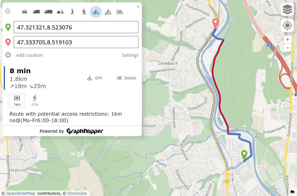
Conditional access was previously enabled by default and it made problems like that you couldn’t plan a route in winter for your summer hiking tour. We’ve changed the approach so these roads are now accessible for walking and biking by default. At the same time we added path details like access_conditional to allow end user applications to display a warning for potential obstacles on the route. You can already see this on GraphHopper Maps: click on the route hint icons below the distance information to get more information about the hint.
We also refined the turn instructions to better guide you when driving a car. Additionally, there are some interesting improvements for the walking and biking modes.
We added explicit support for the transportation modes “bus” and “hov“. Support for “wheelchair” was removed as we think the old version wasn’t fully production ready and a better version should better be created based on a custom model. Let us know if you are interested in working on this or another improvement!
The new routing engine release also includes an improved version of GraphHopper Maps. It comes with an improved GPX export, updated translations, many bug fixes, more route hints like hike_rating and mtb_rating (“sac_scale”) and conditional access information. Route hints were already clickable before, but they have been slightly improved. E.g. the country route hint shows only the two involved countries for the specific border instead of all countries and every click moves you to the next border crossing in the route.
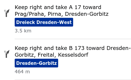
The exits or junctions of a motorway are now highlighted in the turn instructions with the name:
Visit the full change log here.
Happy routing!
